Yellowknife is weird. I mean that in the best possible way, but if you look at a map of Yellowknife NWT for the first time, you’ll probably be confused. You see a city that looks like it was dropped by a giant into a maze of water and jagged rock. There are neighborhoods that feel like standard suburbs and then, suddenly, a district where the houses are painted neon purple and sit on literal houseboats.
It’s the capital of the Northwest Territories, but it doesn't feel like a "capital" in the way Ottawa or Washington does. It’s a frontier town that grew up too fast because of gold, then stayed for the diamonds.
If you're planning to visit, or if you're just obsessed with northern geography, you need more than just a GPS. GPS actually fails people here quite a bit, especially in the "Old Town" area where the roads follow the contours of the Precambrian Shield rather than any logical grid. You need to understand the layers of the land.
Why a Map of Yellowknife NWT is More Complicated Than You Think
Yellowknife isn't flat. It’s built on some of the oldest rock on the planet. When you look at a topographical map, you’ll notice the city is basically a peninsula poking into Great Slave Lake—the deepest lake in North America. This isn't just a fun trivia fact; it dictates everything about how the city breathes.
The city is essentially split into three distinct zones.
First, there’s the "New Town" or Downtown. This is where the high-rises are. Yes, Yellowknife has a skyline. It’s where you’ll find the post office, the banks, and the government buildings. The streets here actually follow a grid (50th Street, 50th Avenue), which makes it the only part of the city where a standard map of Yellowknife NWT feels predictable.
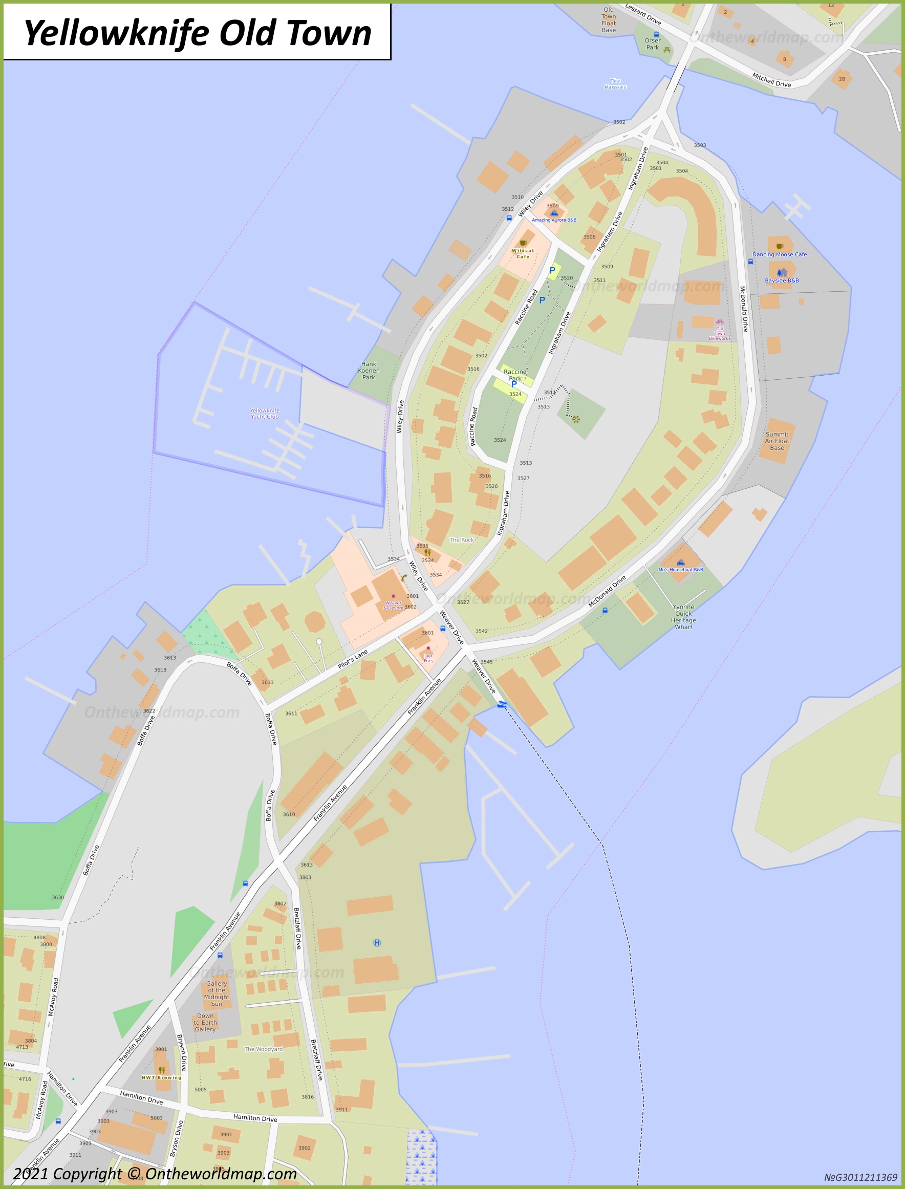
Then you have the "Old Town" and the "Woodyard." This is the soul of the city.
In Old Town, the roads wind around massive rock outcrops. You’ll be walking down a street and suddenly realize someone’s front door is ten feet above your head because their house is bolted to a cliff. A map here looks like a bowl of spaghetti. If you aren't looking at the elevation markers, you’re going to get lost or wind up hiking a staircase you didn't prepare for.
Finally, there are the outlying areas like Kam Lake and Niven Lake. These are the newer residential and industrial hubs. They’re sprawling. If you’re trying to find a specific mechanic or a boutique glass-blowing studio, you’re going to be driving through what feels like a massive construction zone or a pristine forest, depending on which way you turn the steering wheel.
The Great Slave Lake Factor
You can't talk about a map of this area without talking about the water. Great Slave Lake is massive. It’s over 600 meters deep in some spots.
During the summer, the map shows blue water. During the winter? That blue becomes a highway.
This is something that messes with visitors' heads. From roughly late December to April, the "Dettah Ice Road" appears on the map. It’s a literal road plowed across the frozen lake that connects Yellowknife to the Indigenous community of Dettah. It cuts a 20-minute drive down to about five minutes. When you’re looking at a map of Yellowknife NWT in the winter, you have to treat the lake as land.
But don't try that in May. Or October. Unless you want to become a local news headline.
Navigating the Famous "Inland" Trails
Most people think of maps as tools for cars. In the North, maps are for boots and skis.
Yellowknife is surrounded by a network of trails that are better mapped by the local hiking community than by Google. The Frame Lake Trail is the big one. It circles the lake right in the middle of the city. If you look at the map, it seems like a simple loop. It isn't.
The back half of the Frame Lake Trail—the part furthest from the Bristol Monument—is rugged. We’re talking about scrambling over mossy rocks and dodging swampy patches.
Then there’s the Prospector’s Trail near Fred Henne Territorial Park.
If you look at a geological map of Yellowknife NWT, this area is a goldmine—literally. The rocks here are part of the Yellowknife Greenstone Belt. You can see the scars in the earth where prospectors literally scraped away the surface looking for quartz veins.
- Pro-tip: If you’re hiking these trails, use an app like AllTrails but download the offline version. Cell service is great in the city, but once you drop behind a massive granite ridge, your bars might disappear.
The Mystery of the "Houseboat" District
If you look at a satellite map of Yellowknife, specifically in Yellowknife Bay, you’ll see these colorful squares in the water. Those aren't docks. Those are houses.
Yellowknife has one of the only off-grid houseboat communities in Canada that operates year-round. They don't have property taxes because they aren't on land. They don't have "addresses" in the traditional sense.
If you’re trying to find someone out there, your map is basically "look for the red house near the big rock." In the winter, they trek across the ice to get to their cars parked on the shore. In the summer, they use canoes. It is a logistical nightmare that locals have turned into a beautiful art form.
Understanding the "Alphabet" Streets
When you get into the residential bits of New Town, you'll see a pattern that actually makes sense.
The streets are often named after pilots or historical figures. You’ve got Wiley Road, Franklin Avenue (the main drag), and others. But honestly, even with a map, the easiest way to navigate is by landmarks.
"Turn left at the A&W." "Go past the big 'Welcome to Yellowknife' sign." "If you hit the airport, you went too far."
Yellowknife is small enough that you can walk across the main "city" part in about 30 minutes, but the scale is deceptive. Because the air is so clear and there are fewer tall buildings than in Toronto or Vancouver, things look closer than they are. That hill on your map of Yellowknife NWT might look like a gentle slope, but at -30 degrees Celsius, it feels like Everest.
The Industrial Legacy on the Map
You might notice large, empty-looking chunks of land on the northern and eastern edges of the city map. These are the old mine sites—Con Mine and Giant Mine.
You can’t just wander onto these.
Giant Mine, in particular, is a massive remediation project. It’s one of the most contaminated sites in Canada because of the arsenic trioxide stored underground. When you look at the map, you see a lot of "restricted" or "fenced" areas. Respect those lines. They aren't just being bureaucratic; they’re keeping you away from some pretty nasty legacy industrial waste.
On the flip side, the Con Mine area is slowly being integrated back into the city. The iconic Robertson Headframe—the tallest structure in the Northwest Territories—stood there for decades as a landmark for pilots and hikers alike. It’s gone now, but the map still reflects that industrial footprint.
How to Actually Use This Information
If you are heading up there, don't just rely on your phone.
- Get a Paper Map: Go to the Visitor Centre (now located in the lower level of the lopp-sided looking City Hall building). They have fantastic, high-detail maps that show the "shortcuts" through the rocks.
- Check the Season: A map of Yellowknife in July is a map of water. A map in February is a map of ice. Know which one you are standing on.
- Respect the Elevation: If the map shows a bunch of tight contour lines in Old Town, expect stairs. Lots of them.
- Watch the "End of the Road": If you drive out on the Ingraham Trail (Highway 4), your map will show it continuing for miles. It eventually ends at Tibbitt Lake. Beyond that, it's all "Winter Road" territory—only accessible to heavy trucks heading to the diamond mines. Don't try to take your rental car up there in January.
Yellowknife is a place that rewards people who actually look at the ground they are standing on. The map is just a suggestion; the rock is the reality. Whether you're hunting for the Aurora Borealis or just trying to find a decent pint at the Woodyard Brewhouse, understanding the layout of this subarctic outpost is the difference between a great trip and a very cold, very confusing walk.
The best part? Once you learn the "logic" of the city—how the Old Town curves and how the New Town blocks out the wind—you stop needing the map entirely. You just follow the smell of the woodsmoke and the glow of the lights reflecting off the bay.
Actually, scratch that. Keep the map. It’s easy to get turned around when the sun doesn't set in June or doesn't really rise in December.
Actionable Next Steps
- Download Offline Maps: Before you land at YZF, download the entire Yellowknife region on Google Maps. Data can be spotty and expensive in the North.
- Identify the "Pilot’s Monument": Locate this on your map immediately. It’s the highest point in Old Town and serves as a 360-degree North Star for navigation.
- Study the Ingraham Trail: If you plan on seeing the Aurora, map out the boat launches and day-use areas (like Prelude Lake or Reid Lake) along Highway 4 before you head out in the dark.
- Verify the Ice Road Status: If visiting in winter, check the NWT Department of Infrastructure website to see if the Dettah Ice Road is officially "Open" before following your GPS onto the lake.