Zambia is shaped like a giant, distorted butterfly. Honestly, just look at it. If you pull up a map of Zambia Africa, you’ll see this weirdly cinched middle—the Pedicle—where the Democratic Republic of the Congo almost slices the country in half. It’s a geographical quirk that defines everything from how people travel to how the economy breathes.
Most people just see a landlocked blotch in the middle of Southern Africa. They’re missing the point. Zambia isn't just "near" the Victoria Falls; it is a massive, sprawling plateau roughly the size of France, the Netherlands, Belgium, and Switzerland combined. That’s a lot of ground. It borders eight different countries, which makes its map look like a jigsaw puzzle gone wrong. You've got Angola to the west, Namibia, Botswana, and Zimbabwe to the south, Mozambique and Malawi to the east, and Tanzania and the DRC to the north.
It's a crossroads. Literally.
Navigating the Copperbelt and the Line of Rail
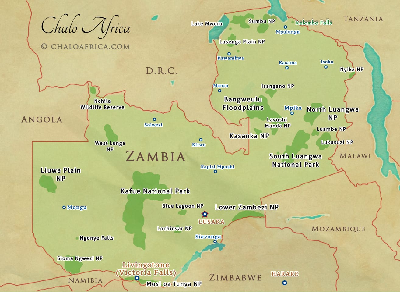
If you’re staring at a map of Zambia Africa for the first time, your eyes will probably gravitate toward the "Line of Rail." This isn't just a train track. It’s the spine of the nation. It runs from the Victoria Falls in the south, up through the capital city of Lusaka, and snakes into the Copperbelt Province.
The Copperbelt is the engine room. Cities like Ndola and Kitwe don't get the tourist love that Livingstone does, but they are where the money is made. This region is dense. It’s industrial. Geologists and mining experts like those from the Zambia Chamber of Mines often point out that this tiny northern strip holds some of the world’s highest-grade copper deposits. If you're looking at a physical map, notice how the elevation stays high here. You’re on a plateau. It’s not the sweaty, low-lying jungle people expect when they think of "Central Africa." It’s actually quite temperate.
Then there’s Lusaka. It’s right in the middle. It’s a sprawling, chaotic hub where every major road on the map eventually converges. You can’t go from the east to the west without hitting Lusaka. It's the ultimate bottleneck.
The Water That Defines the Borders
Borders are usually just lines on a piece of paper drawn by guys in Europe a hundred years ago. In Zambia, the water actually does a lot of the work.
Take the Zambezi River. It’s the fourth-longest river in Africa and it basically creates the entire southern border with Zimbabwe. When you look at the map of Zambia Africa, follow that blue line. It flows into Lake Kariba—the world's largest man-made lake by volume. Kariba is so heavy that it has actually caused seismic activity in the region. It’s an inland sea. If you’re visiting, you’ll see the Kariba Dam, an engineering marvel that provides most of the country’s electricity.
- Lake Tanganyika: In the far north, Zambia gets a tiny, precious slice of the world's longest freshwater lake.
- Lake Bangweulu: This means "where the sky meets the water." It’s not just a lake; it’s a massive swamp system. It’s where the elusive Shoebill stork lives.
- Lake Mweru: Tucked away on the border with the DRC, it’s a major fishing hub that rarely sees a foreigner.
Then there is the Luangwa River. This is the lifeblood of the South Luangwa National Park. Unlike the Zambezi, which is dammed and controlled, the Luangwa is "wild." It meanders. It creates oxbow lakes. On a topographic map, you can see how the river has carved a deep valley that acts as a natural sanctuary for hippos and leopards.
The Regions Most People Miss
The Western Province is a world of its own. It’s called Barotseland by the locals. If you look at a map of Zambia Africa, the west is dominated by the Barotse Floodplain. Every year, the Zambezi overflows and covers an area the size of a small country. The Lozi people have a ceremony called the Kuomboka, where the King (the Litunga) moves from his summer palace on the plain to his winter palace on higher ground.
It’s one of the few places on earth where the map literally changes every six months. Roads disappear. Villages become islands. You need a boat or a very expensive 4x4 to get around.
Down in the south, you have the Gwembe Valley. It’s hot. Bone-dry. It’s a stark contrast to the lush, rainy forests of the North-Western Province. Speaking of the North-West, that’s the "New Copperbelt." Places like Solwezi are booming. Ten years ago, they were sleepy outposts. Now, they are the fastest-growing spots on the map thanks to mines like Kansanshi and Sentinel.
A Note on Roads and Reality
Don't trust the "Estimated Time of Arrival" on Google Maps when looking at Zambia. Just don't.
The Great North Road is a legend, but it’s also a nightmare of heavy trucks carrying copper to the Tanzanian port of Dar es Salaam. The T3 is the lifeblood of the Copperbelt. Then you have the Great East Road, which takes you toward Malawi. It’s beautiful, winding through the hills of the Eastern Province, but it's a long haul.
A map tells you the distance between Lusaka and Chipata is about 600 kilometers. On paper, that’s a six-hour drive. In reality? It’s eight to ten. You’ve got checkpoints, potholes the size of bathtubs, and the occasional elephant crossing.
The Geographic "Anomalies"
Zambia has these pockets of weirdness. Look at the Muchinga Escarpment. It’s a massive ridge that separates the Luangwa Valley from the central plateau. It’s a brutal climb for any vehicle. Then there’s the Nyika Plateau in the northeast, which Zambia shares with Malawi. It’s high-altitude grassland. It looks more like the Scottish Highlands than Africa. You’ll find wildflowers and cold mists there that feel totally out of place.
People often ask about the "Caprivi Strip." That’s that weird finger of Namibia that reaches out and touches the Zambezi near Kazungula. If you look at the map of Zambia Africa right at that southern tip, you’ll see the world’s only "quadripoint"—where Botswana, Namibia, Zambia, and Zimbabwe almost meet at a single point in the river. It’s a logistical headache for border control but a fascinating spot for map nerds.
Realities of the Landlocked Status
Being landlocked is Zambia’s biggest challenge. Everything has to come in via truck or rail from ports in South Africa, Namibia, Mozambique, or Tanzania. This makes "The Map" an obsession for local economists. They talk about "corridors."
- The Walvis Bay Corridor (through Namibia)
- The Beira Corridor (through Mozambique)
- The Dar es Salaam Corridor (through Tanzania)
When one of these borders closes or a bridge goes down, the price of fuel in Lusaka spikes within days. The geography dictates the cost of living.
What You Should Actually Do With This Information
If you’re planning a trip or researching the region, stop looking at Zambia as a single destination. It’s a collection of biomes.
For the Safari Addict: Focus your map search on the "Eastern Province" (South Luangwa) and "Lower Zambezi." These are the gold standards. The wildlife density here is absurd.
For the Adventure Junkie: Look at the "Northern Province." Go find Kalambo Falls on the border with Tanzania. It’s a single-drop waterfall twice as high as Victoria Falls. Hardly anyone goes there because the map says it’s "too far." It’s not. It’s just an adventure.
For the Business Traveler: Stick to the "Line of Rail." Lusaka, Ndola, Kitwe, and Solwezi. This is where the infrastructure is. This is where the fiber-optic cables run.
For the Culture Seeker: Head West. The Barotse Floodplain is a cultural landscape recognized by UNESCO. It’s a place where geography and tradition are the same thing.
Actionable Next Steps for Mapping Zambia
- Download Offline Maps: If you are actually traveling, do not rely on a live data connection. Use Organic Maps or Google Maps offline. Significant chunks of the North-Western and Western provinces have zero cell coverage.
- Check the Seasonal Floods: If your map shows a "road" across the Bangweulu Wetlands or the Barotse Floodplain, verify the month. From February to May, those roads are often underwater.
- Use the T3 and T2 Designations: Local directions often use "The Great North Road" or "The Great East Road" rather than highway numbers. Learn the nicknames of the roads to save yourself a lot of confusion at fuel stations.
- Verify Border Hours: Just because a map shows a crossing (like the one at Kariba or Chirundu) doesn't mean it's 24 hours. Most Zambia borders close at 18:00 or 20:00. Chirundu is one of the few that stays open later, but it's notorious for truck congestion.
- Cross-Reference with Satellite Imagery: Standard map views often miss the sheer scale of the mining pits in the Copperbelt or the density of the bush in the Kafue National Park. Use satellite layers to understand the terrain you're actually entering.