Static weather warnings fundamentally fail to account for the collision of localized meteorological volatility and rigid cultural transit demands. When the Hong Kong Observatory issued a localized alert for intense thundery showers over the seas south of the city, its standard communication model addressed atmospheric conditions rather than the systemic risk of mass human transit.
The convergence of this sudden weather system with the Ching Ming Festival represents a predictable friction point in urban load management. Traditional reporting focuses on the warning itself. A rigorous operational analysis must instead dissect the structural friction between predictable cultural spikes and unpredictable environmental inputs. You might also find this related coverage useful: The Broken Mechanics of the East Coast Flight Grid.
The Friction Between Cultural Rigidity and Atmospheric Volatility
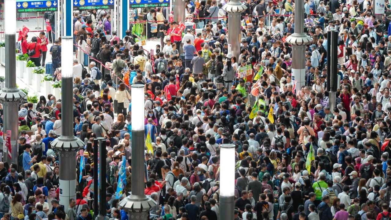
Urban systems are designed to handle variable but predictable loads. The Ching Ming Festival introduces a non-negotiable spike in transit demand. Millions of residents mobilize toward specific geographic nodes—predominantly hillside columbaria and cemeteries—within a highly compressed temporal window.
The system failure occurs because the cultural event is time-rigid while the meteorological event is highly dynamic. As reported in detailed coverage by Lonely Planet, the effects are widespread.
This creates a specific bottleneck defined by three distinct variables:
- The Fixed-Destination Constraint: Unlike standard weekend leisure travel, where participants can alter destinations based on weather, Ching Ming traffic is strictly bound to specific burial sites (e.g., Wo Hop Shek, Cape Collinson, and Tseung Kwan O). Demand cannot be redistributed to other nodes.
- The Temporal Compression Factor: Ancestral rituals are traditionally executed during the morning and early afternoon. Any weather disruption during this window does not cancel the demand; it merely compresses it into a shorter, more dangerous timeframe or forces travel through active squalls.
- The Infrastructure Vulnerability Index: Hong Kong’s cemetery sites are predominantly located on steep terrain. Intense rainfall drastically increases the risk of localized landslides and reduces the friction coefficient of walking surfaces, compounding the difficulty of crowd control.
Standard government responses rely on predictable crowd-control protocols. Authorities implemented special traffic arrangements across major districts including Chai Wan, Aberdeen, Diamond Hill, and Sha Tin. The strategic flaw in this approach is that it is reactive and relies on public compliance rather than active demand management.
The Mechanism of the Squall Line Squeeze
The meteorology of the Pearl River Delta during the spring transition depends heavily on the movement of troughs of low pressure. The specific event cited by the forecaster—a band of intense thundery showers edging closer from the south—creates a specific mechanical impact on the city’s transit infrastructure.
To understand the cause-and-effect relationship missed by standard reporting, one must map the sequence of infrastructure degradation during a localized squall:
- Phase 1: Visual and Psychological Friction: As the band of showers approaches, visibility drops. Private drivers and bus operators naturally decrease speed, reducing the throughput capacity of narrow access roads leading to hillside cemeteries.
- Phase 2: Modality Shift and Overload: Light rain prompts pedestrians to open umbrellas, effectively doubling the physical footprint of each individual on narrow footpaths. Intense rain causes pedestrians to abandon walking routes entirely, seeking immediate shelter or flooding public transport boarding points simultaneously.
- Phase 3: The Deadweight Loss of Static Scheduling: Government appeals for citizens to use public transport assume that public transport has infinite elastic capacity. When thousands of people arrive at a terminal like Chai Wan or Tsuen Wan simultaneously to escape a downpour, the station becomes a high-density choke point where ingress exceeds egress capability.
The Observatory's instruction that "members of the public should be aware of the change in weather" provides no tactical utility. It transfers the burden of risk calculation from the institution to the individual, who lacks the data to make an optimized decision.
Systemic Limitations of Public Advisory Frameworks
The core limitation of existing meteorological and municipal strategies lies in the separation of powers. The meteorological body measures atmosphere; the transport department measures vehicles. Neither actively calculates the combined risk score of both systems interacting in real time.
This fragmentation creates severe structural blind spots:
- Information Asymmetry: The public is told that showers are approaching but not how those showers will impact specific transit routes in real time. An individual cannot calculate whether a journey to Wo Hop Shek will take 45 minutes or 3 hours until they are already trapped in the system.
- The Compliance Myth: Advising the public to use public transport during a localized storm often exacerbates the problem. Mass transit systems have fixed capacities. When a surge of users enters the system to avoid rain, the resulting density creates severe safety hazards at transfer stations.
To optimize urban movement during these critical intersections, municipal authorities must move away from static warnings toward a model of dynamic load management.
Instead of issuing blanket statements, predictive modeling must be used to calculate the absorption capacity of specific cemetery access points under varying rainfall intensities. When the rainfall rate exceeds the drainage and pedestrian capacity of a site like Cape Collinson, transport feeder services should be dynamically throttled at the source stations to prevent dangerous crowd densities at the destination. The final strategic play requires shifting from measuring the weather to actively measuring and controlling the human kinetic response to it.